.gif)

9.20.2006
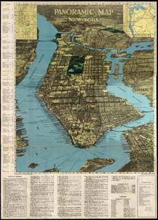
NYC Panoramic Map
While blogging recently, I came across this map. It's a panoramic map, dating from the mid 20th century [I'm guessing 1940's due to the printing technique and the colour]. This map 'roughly' breaks the city into different areas at an oblique angle. It's really mindblowing.
My favorite part is the "Ghetto" label over the entire Chinatown and LES. Funny. Anyway, enjoy and sorry, but I cannot find the original site. If you're the owner, please contact me and i'll hyperlink your blog. If you are interested in the original [20mb] file at 4000 x 2000 resolution, email me. Cheers.
Subscribe to:
Post Comments (Atom)


No comments:
Post a Comment